

Innovative solutions for karst exploration and environmental insights
With a strong foundation in environmental science, we combine cutting-edge technology with extensive field experince to provide specialized solutions for karst and underground research
SERVICES
Whether analyzing LiDAR data, deploying off-grid surveillance for wildlife studies, conducting detailed underground surveys, or monitoring hydrogeological systems, our services are designed to support exploration, monitoring, and decision-making in remote and complex terrains.

LiDAR data analysis

Hydrogeological monitoring

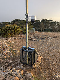
Off-grid video surveillance systems

Rope access

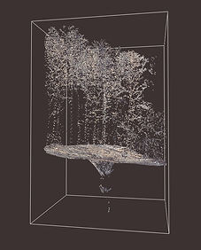
Underground survey and 3D mapping

GIS applications
FEATURED PROJECTS


LATEST NEWS


Vultures in the Snow
11 January 2026
Cold air from the north has brought winter to the Kvarner region over the past few days. Snow covered the griffon vulture feeding site at Strganac, and our cameras, installed in cooperation with the Public Institution "Priroda", captured these quiet mornings.
At the same time, while we stare at the snow and put on yet another layer of clothing, a mother vulture on the island of Plavnik stoically braves the freezing wind, calmly lying on her egg - yet another proof that nature doesn't check the weather forecast.
Scenes like these, watched from the comfort of our living room, are a great reminder of why we love combining fieldwork with technology: because life doesn't happen when it's convenient, but all the time. Projects that make this possible, such as the LIFE SUPport project by the Biom Association, Public Institution "Priroda", and other partners, are becoming an invaluable source of data crucial for understanding the Kvarner population of Griffon vultures.
We set up the cameras but nature is the real director. 🎥