3D LiDAR mapping of Rašpor Pit, the deepest cave in Istria
Mapping and monitoring for sustainable tourism in Zovnjača cave
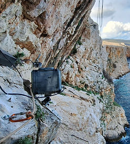
Employing solar-powered remote video monitoring to assess tourism impact on Plavnik Island vulture colonies
Off-grid video monitoring for griffon vulture conservation - Strganac vulture restaurant
Rapid-response (bio)speleological support on the Istrian Y project enabling uninterrupted construction in karst terrain
High-quality, low-impact filming of griffon vultures for a blue-chip documentary
LiDAR and GIS analysis for mapping potential speleological features in the Kristal spring catchment
High-resolution LiDAR analysis and cadastre of potential speleological features in Medvednica nature park